The start of it

For a long time, whilst out walking in the Sierra Nevada Mountains, we have come across footpath signs to Sulayr but we were never able to connect the signs to any known path, they always seemed to point to somewhere high in the Sierra Nevada. Then in August 2009 whilst on the Mulhacen mountain bus Paco, the guide, explained that it was a 300 km circular path running around the Sierra Nevada National park.
Slowly my interest in this walk was aroused, but it always looked like it would be a ambition never undertaken. The path runs around the Sierras at about 2000 meters, and the thought of taking our poor little Renault Kangoo up all those access tracks to the start of a new section of the walk filled me with dread, it was our only car.
In 2011 the chance came to buy another car, and the thought of walking the Sulayr path gained momentum. What was needed were some good buddies to share the experience. My wife has always classed the “The A Team” of the Lecrin Valley Limpers as something out of “The Last of the Summer Wine”. A group of old men who go out in to the mountains for the day and come home raggy arsed, tired and dirty. After careful consultation with fellow team members who jumped at the chance of expeditions into the high Sierras I decided to buy a small 4X4.
This is the story as it unfolds.

Thursday, June 14, 2012

June 10 2012 Section 19 Visitor centre to Vereda Estrella


The end of the walk .


June 10 2012 Section 19 Visitor centre to Vereda Estrella


We did it. Finally after all these weeks we joined the circle up and completed the last section down to Estrella.
It was quite sad to think that our walk was nearly complete, the project has kept us amused for so long, each week we had another section to finish.
We had saved the last section to the end. I know that sounds pretty obvious, but the way we had chosen to do the walk, in separate unconnected stages, enabled us to fit the walk in around different weather conditions on the northern and southern slopes. There were different  time requirements for doing the middle sections up in Almeria province, which took up a lot of traveling time. We could also see the same region in different seasons, we may have finished one section in the Spring and then went back to do the following one in the Autumn, but we had kept this last section so that the end of the book was the end of the walk.
The walk started from the Visitor centre on the Sierra Nevada road, the official start and finishing point of the Sulayr path. The track follows a paved road as it heads down towards Gúéjar Sierra. I can only remember walking on one other section of paved road in Capileira, and as they were both very quiet roads we can let it go.
The road winds its way down through some very lush countryside, past some very imposing houses that are dotted along the hillside. We had not travelled far when we were joined by a dog who seemed keen to show us the way. He probably spends every day waiting to guide befuddled old gits on this section of the Sulayr. In the end we named him Sue after the Sulayr path.
After 4 kms we left the road and picked up a forest track as it headed into the San Juan valley, this is a great area and we will return to do some further exploratory walks soon.
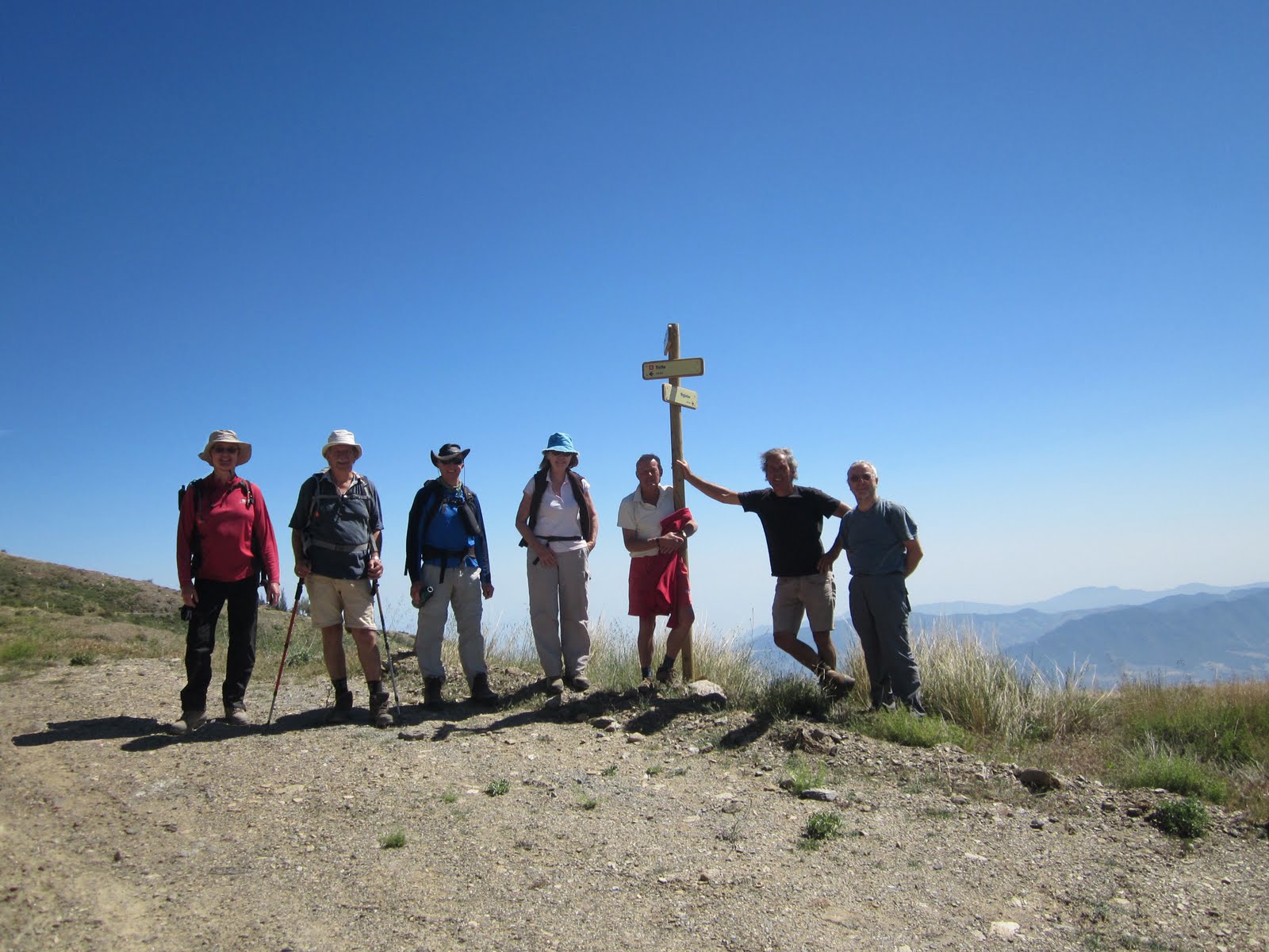
We stopped for a little lunch at la Hortichela, a delightful wooded area, before setting off for the final short walk down to the Vereda Estrella. Just as we arrived at the Junction with the Estrella path, and the end of our 300 km trek, a very nice young lady from the Medio Ambiente arrived. Normally when you get to the end of a long distance path there is no one there to welcome you, to say well done, but we had an official from the authority responsible for the whole Sierra Nevada National park. I could not have arranged it better if King Juan Carlos had been there! I told the group I had arranged for her to be here to welcome us.
After the obligatory photo opportunity we turned around and headed back towards our starting  point. We were expecting Sue to leave us as we passed his house, but no, he continued with us back to the cars.
You can’t celebrate the end of a long distance walk without a bottle of Champagne, well you can in Spain, you spend €2.55 buying a bottle of Cava from Diá. We celebrated in style, nine people to one bottle, and then headed for the bar. To our surprise Sue also joined us, the Camerero knew where he lived so we left him there.
In the afternoon the celebrations continued around at Mike and Sheila’s.
The Sulayr path has been an incredible journey for us, every walk has been different and very enjoyable, the final section today was a fitting end to our adventure.         


The walkers; Mike, Kees, Ray, Graham, Rene, Mark, José, Daniella and myself.

Distance walked on route today,7.4 km. Total distance today 15.4 km. Height climbed today 585 metres. Total distance walked on the Sulayr path 299.3 km. Distance left to do 0.7 km. Total height climbed 24394 metres. Total distance walked 671.5 km.  

Somehow along the route we lost 0.7 km, we don’t know where it went, someday we may have to go back and re-measure the distances.


Addendum
Whilst inking the route into my maps I discovered the missing .7 km. When we had done the Trevelez sections we had walked out of the village on one walk. The next time we walked into Trevelez we had caught the bus back to Capileira from the outskirts of the village and never completed the route through the village. We all blamed Ray for this oversight and returned to Trevelez on the 19th June 2012 to finish it off. We could not have lived with ourselves otherwise. It was also an excuse to go and do another a fabulous walk from there.  

Footnote
When we had originally planned the walk there were going to be five of us, Mike, Kees, Ray, Graham and myself. A totally boy’s own adventure, this did not go down well with the girls in the group, we were accused of being sexist,  being old gits someone had to explain what sex is.
In the end we relented and allowed them to join us, subject to them not whinging when conditions got tough.
It soon became apparent that Ray and Graham would not be able to complete every section as they were not living here permanently. So it was down to Kees, Mike and myself to walk the full distance, with the others walking when they were around. We weren’t able to walk every week, most of the walk is at an altitude of around 2000 metres so in the winter it is covered in snow, in the summer it is too hot, and there were holidays and sickness to contend with.
I must single Rene out for special mention, not only was there no moaning, except for our occasional choice of bar in Cadiar, on most of the walks she out walked us.
Mark gets a special mention for taking his poor little Renault van up some very rough off road bits.
Plym gets a mention for her minimalist approach to walking, whilst the rest of us were taking full packs, stuffed with food, drinks and spare clothing. Plym would turn up with a banana, but only if it was going to be a long walk.
Ray gets a mention for being so quiet, there were times on the long car journeys when I had to keep checking in the mirror to make sure he had not fallen out of the car.
Graham for his unstinting controversial comments.
Finally Mike and Kees, without them and their unshakable belief that I knew where we were going the walk would never have been completed.

Hopefully we will try and and put it all down in a book so we all have a permanent record of what must be one of the best walks ever devised.  

Thursday, June 7, 2012

5 June 2012 Section 3 Rinconada de Nigúelas - Loma de Las Tres Encinas.


Loma de Las Tres Encinas. 

5 June 2012 Section 3  Rinconada de Nigúelas - Loma de Las Tres Encinas.

Well we are nearly there, we are on the penultimate walk, a short section from Loma de las Tres Encinas to Rinconada de Nigúelas. Everyone was looking forward to this section, at only 7.5 km and 300 metres of climbing it was going to be easy, in fact the easiest section of them all. I could see their eyes gleaming with the thought that they would be sat in Miguel’s Bar in Nigúelas by 1 pm. It seemed a waste of such a glorious day, to spend it in a bar, when we could be on top of a 3000 metre mountain. The Sulayr path skirts along the flanks of Caballo so why not do a little bit of extra climbing and find somewhere with a fine view for lunch.
 We had an 8 am start from Nigúelas for the 35 minute drive up to Loma de Las Encinas. The last time we were here was the 13 May 2011, that seems a while ago now. This section of the Sulayr is all on a high altitude mountain road as it skirts around the head waters of the Rio Torrente. The original plan was turn off the road after 1.5 km and find a little path heading up the Loma de Caballo, but we could not find any sign of it, so instead we decided to press on for the Riconada where we had finished up last week, where we arrived after 1.5 hours of walking and had not even raised a sweat.
 When we got there we found a party of walkers who driven up from Malaga who were also planning to go up Caballo. This is the first group of walkers we have seen for 12 months, we have long accepted that these mountains are ours, it was like we had discovered trespassers on our land. We stopped for a little refreshment and let them get a head start, thinking that we would not see them again, after all we are all old gits!
 To start with the path up from the Riconada is quite steep and we soon overhauled them, coming from Malaga they were not used to such high altitudes. This path up Cabello is a great way up, the summit is in view virtually the whole way and you head straight for it, no zig zagging, no loss of height, no false summits and good views all the way, a fantastic path. We stopped for lunch at the top and enjoyed the 360 degree panoramic views. It also gave us time to study our future expeditions, for next week we won’t have our Sulayr walk to do because we are planning to finish the last section on Sunday.
 After lunch, and fully recovered from our highest climb so far this year, the first of the Malaga guys arrived, so leaving them to enjoy the summit in peace we set off back down the hill. The beauty of this walk was that it is a circular walk up a 3011 metre mountain with no steep sections.
The path is easy to follow as it makes its way down the hillside and we passed a lot of Cabra that were secreted in the hillocks. The hardest part is the last 3 km when you come to a forest road that zig zags back to the cars, you can see them in the distance, just when you think you are nearly back you realise there are still 3 kilometers to go, but at least it is not hard on the knees.
 Arriving back at the cars we were stopped by a Little Bo Peep who wanted to know if we had seen any sheep, apparently she had fallen asleep and when she awoke she did not know where to find them. We told her we had seen a big herd of Cabra, but this did not appear to be any help to her. We then wished her well and she drove off in her Toyota Land Cruiser to look for them. How times change!
 We headed back to Nigúelas for a well earned beer and tapas in Migúels bar.

The walkers; Mike, Kees, Ray, Graham, Rene, Mark,  and myself.

Distance walked on route today,7.1 km. Total distance today 21.5 km. Height climbed today 1209 metres. Total distance walked on the Sulayr path 291.9 km. Distance left to do 8.1 km. Total height climbed 23809 metres. Total distance walked 656.1 km.


Friday, June 1, 2012

29 May 2012 Section 2 La Cortijuela - Rinconada de Nigúelas


Rio Dilar

29 May 2012 Section 2 La Cortijuela - Rinconada de Nigúelas

We organised things a little differently this week, we hired a Taxi. A few weeks ago I was talking with a friend, Antonio, and he mentioned that he had a 4x4 9 seater Land Rover and that he ferried groups of walkers on walking trips. This set me wondering how we could utilize his services for our mid week walks. One of the main problems with the Sulayr walk has been access up to the path. Because most of the walk has been in areas new to us, and access to the path is usually aboout 15 km up a forest road, it would be difficult to get someone to drop us off and meet us again 20 km away at a place we didn’t know you can even get a car to. That is why for most of the walk we have walked out and returned back to the car, at least we knew where it was.
The last big section we had left to do, tramo 2 from La Cortijuela to the Rinconada de Nigúelas, was different. We knew both the start and finish point, and we also knew that we could get a car, or specifically a 4X4, to both places. I talked it over with the team and Antonio and agreed a price for his services and as they say the rest was easy.
We met in Nigúelas at 8 a.m. for the journey to La Cortijuela, which is better known as the Botanical gardens above Cumbres Verde, and an hour later he dropped us off at our start point. We have kept putting this walk off either because it was too cold, too hot, too much snow, too windy but today it was perfect, clear blue skies and a little breeze.
The walk starts by following the forest road as climbs up past Trevenque, we have walked part of this road before but after 3km we were into some spectacular virgin territory as the path turned down towards the Rio Dilar. We stopped for a photo at the river crossing before climbing up the steep sided bank onto Loma de Peñamadura. The biggest surprise was the number of abandoned Cortijos, miles from anywhere that could have only been served by mule trails.
Food is always a big consideration on our walks, especially when Graham is about. We don’t normally eat much while we are climbing, preferring to have lunch at the highest point of the walk. Unfortunately the summit was at the finish, and there were 2 descents and 3 climbs before we got there, so a series of little lunches were taken, to keep body and soul together. Graham’s knee was still playing up and, on one occasion, he preferred to keep walking rather than stop for refreshment. In all the years I have known him he has never missed a sandwich stop!
Loma de Peñamadura is a magnificent hillside to walk across, it lies between the rios Dilar and Durcal and there are stunning views over Picacho Alta, Granada and Caballo.
Dropping down into the Rio Durcal we came across the source of the water for the Hydro-electric plant in Durcal. What a tortuous route that must take when you see the terrain it has to travel through.
Over the past few weeks we have noticed a lot of workmen with strimmers working by the side of the forest roads, carefully cutting the vegetation back. Today we came across another 8 on a road to nowhere, miles from anywhere, strimming the hillside, shortly the whole Sierra Nevada will be strimmed and no doubt polished. Surely if it is job creation there are far more productive things that could be done, they could be operating the printing presses, printing all those new Peseta notes which will be needed in the next few weeks.
From the Rio Durcal it is a 7.3 km, 540 metre climb to the end of tramo 2 and, coming at the end of the walk in the heat of the day, you certainly know you have done it.
We arrived at the Rinconada de Nigúelas with about 20 minutes to spare, and in the distance we could see Antonio and his Land Rover making his way up the valley. It was a good feeling as I did not relish the 4 hour walk down to Nigúelas. We just had enough time to polish off what was left of our sandwiches before he arrived to pick us up.
It’s a long, slow and dusty road back to Nigúelas and we rocked and rolled our way back back down the mountain. Antonio delivered us straight to Miguel's bar on the car park where we all enjoyed double drinks and tapas, the best in the area. This was a great day out and it was good that we could do a complete section in one outing.
Antonio’s taxi service worked well, and we will incorporate it again in some of our future walks.
We now have only two short sections left to do, we should be able to complete them in the next couple of weeks.

The walkers; Mike, Kees, Ray, Graham, Rene, Mark,  and myself.

Distance walked on route today,17.5 km. Total distance today 17.5 km. Height climbed today 1087 metres. Total distance walked on the Sulayr path 284.8 km. Distance left to do 15.2 km. Total height climbed 22600 metres. Total distance walked 634.6 km.